- Joined
- Sep 19, 2017
- Messages
- 49
- Reaction score
- 6
- Age
- 26
Hello everyone,
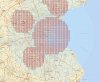
I have a just a brief question. For a commercial drone flight, I know you need authorization from the airport. Awhile back, you just had to call the tower. Now, you have to request the waiver. So for a class E5 airport, you wouldnt have to request a waiver because the lower limit is 700 feet. ( I am using this website BTW: https://faa.maps.arcgis.com ).
Now, for a class E2, you would have to request a waiver correct because it is from the surface up and that follows with Class D.
So if you want to fly in multiple different airspace's, can you do that on one waiver? Like for my area, there are I think 3 airports that are restricting me.