


- Joined
- Jan 30, 2016
- Messages
- 13
- Reaction score
- 5
- Age
- 45
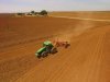
Rice farmers in northern California are preparing their fields to be filled with water and planted with rice. Precisely leveling their fields with centimeter-level RTK GPS means they can achieve uniform water depth, which is really important for maximizing harvest yields. I tried to upload a video, but was informed by the site that it does not have an appropriate extension... I need to look into what I may be doing wrong here. A photo will have to suffice in the meantime. Thanks for looking!
Attachments
Last edited:


