Welcome Inspire Pilots!
Join our free DJI Inspire community today!
Sign up

FAA Facility Maps (LAANC Grids)

BigAl07

Administrator
Staff Member
Joined
Jun 3, 2016
Messages
104
Reaction score
106
Age
53
This comes up a LOT and we need to do a PSA to all FAA UAS operators. On the UAS Facility Maps (LAANC Grids) there are boxes with a # in it (0 - 400). Some people mistakenly think this is the "allowed altitude by default" for that grid section. This is NOT the case. The altitude listed is the MAX altitude you will most likely get approval if you submit a request via LAANC. This is a mere shortcut so that you don't ask for 300' in a 100' location (it will get denied).

Any and EVERY flight inside of Controlled Airspace must be pre-authorized before the UAS takes off. This would be done via LAANC if it's available and your request is "normal". If it's outside of the listed altitude you'll have to submit a manual request via the FAA Drone Zone portal.

It's also important to know that not EVERY submission gets approval even if less than the noted altitude. An active airport is a very DYNAMIC area and things like Emergencies, Military Operations, VIP Activity, Maintenance, and Equipment Failures can alter normal traffic etc and a seemingly simple and routine request CAN get denied.
 
This is good information!

Here's an odd question;

If I'm flying in Class C airspace LOWER than surrounding buildings, do I still need LAANC approval? What I'm trying to flush out here is if there is any common-sense "wiggle room" applied to UAS regulations? Or are we bound by procedure regardless of what common sense dictates? Could we be turned down for a 100' flight if we're surrounded by buildings 120' tall?

D
 
  • Like
Reactions: ZCDC and BigAl07
In my experience that numbers in the boxes are AGL, and do not include object heights in the area. I have had a few frustrating experiences where the box numbers made zero sense. I was flying in areas where the elevation of the city was BELOW the elevation of the airport AND there were 25 story buildings around me. And the box numbers were 200-300'. That made little sense. My other big complaint has always been that DJI's geo-fencing does not match the LAANC. More that once I have had FAA authorization to fly (LAANC), and the geofence grounded me.
 
This is good information!

Here's an odd question;

If I'm flying in Class C airspace LOWER than surrounding buildings, do I still need LAANC approval? What I'm trying to flush out here is if there is any common-sense "wiggle room" applied to UAS regulations? Or are we bound by procedure regardless of what common sense dictates? Could we be turned down for a 100' flight if we're surrounded by buildings 120' tall?

D


So you're wanting the FAA to apply Common Sense? How dare you insinuate such a notion LOL!

No there is no "Deviation".... Flight is Flight is Flight whether it's 5' AGL or 500' AGL. The premise is they still have to allow for Pilot Error, Mechanical Failures, and with many modern UAS the "Return To Home" scenario. Even though you can absolutely fly safely at or below Tree Top Level your RTH may be 200' AGL. Also this gives ATC somewhere to look and someone to contact should something change or go wrong.
 
  • Like
Reactions: Donnie Frank
In my experience that numbers in the boxes are AGL, and do not include object heights in the area.

That is correct. The elevation in the grid cells are Above Ground Level. (TBH, This is kinda obvious. )


and do not include object heights in the area

In controlled airspace requiring a CoA (Including administered by LAANC ) you do not have authorization to fly any higher than the approved AGL altitude. The limit of 400' above an object within 400' horizontal does NOT apply in controlled airspace unless you are specifically granted authorization to do so.

My other big complaint has always been that DJI's geo-fencing does not match the LAANC. More that once I have had FAA authorization to fly (LAANC), and the geofence grounded me.

DJI will eventually get the idea that their helpful geofencing is hurting their bottom line and will get over it. Already you see "No arbitrary geo-fencing" listed as a benefit feature in most craft coming out that compete with DJI. DJI is an inovator in hardware and a Luddite in public policy. And they always have been.
 
  • Like
Reactions: BigAl07
This is good information!

Here's an odd question;

If I'm flying in Class C airspace LOWER than surrounding buildings, do I still need LAANC approval? What I'm trying to flush out here is if there is any common-sense "wiggle room" applied to UAS regulations? Or are we bound by procedure regardless of what common sense dictates? Could we be turned down for a 100' flight if we're surrounded by buildings 120' tall?

D

Donnie, I nearly spit out my coffee reading this man. Common sense wiggle room ??!! I’m not sure I can remember anything the FAA has done that had either common sense or any wiggle room. Of course, I know what you mean and I wish they did too. That’s why we all do what we need to do every now and then. Just the reality of it.
 
This comes up a LOT and we need to do a PSA to all FAA UAS operators. On the UAS Facility Maps (LAANC Grids) there are boxes with a # in it (0 - 400). Some people mistakenly think this is the "allowed altitude by default" for that grid section. This is NOT the case. The altitude listed is the MAX altitude you will most likely get approval if you submit a request via LAANC. This is a mere shortcut so that you don't ask for 300' in a 100' location (it will get denied).

Any and EVERY flight inside of Controlled Airspace must be pre-authorized before the UAS takes off. This would be done via LAANC if it's available and your request is "normal". If it's outside of the listed altitude you'll have to submit a manual request via the FAA Drone Zone portal.

It's also important to know that not EVERY submission gets approval even if less than the noted altitude. An active airport is a very DYNAMIC area and things like Emergencies, Military Operations, VIP Activity, Maintenance, and Equipment Failures can alter normal traffic etc and a seemingly simple and routine request CAN get denied.
Just one clarification. Those heights inside the box indicate LAANC automatic approval heights. If you use LAANC to request a height at or below that height it will be automatically approved or denied. It might be automatically denied for example if the request is for a time outside daylight hours. But if your request is following all part 107 rules your request will be approved because it is automated.

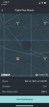
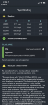
Part 107 pilots are able to request higher approvals through LAANC than the facility map indicates but they will be manually approved or denied by an actual human at the tower. I just a couple weeks ago got 350 ft approval for a 100 ft zone on the facilities map. The FAA called me and gave the phone number to the tower and I had to agree to call them before and after the operation. My operation was not in the runway path so your mileage may be vary.

81C333A3-C16F-49B6-8CA4-09E487AED44B.pngBF036A04-A15D-4178-B07C-E598563417A2.png
 

New Posts

Members online

Forum statistics

Threads
22,290
Messages
210,729
Members
34,479
Latest member
redrocksshuttle