Welcome Inspire Pilots!
Join our free DJI Inspire community today!
Sign up

Flights above 400 feet

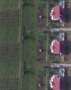
I think the overlap is that high so they can reconstruct the elevation maps, not just for high number stiching points, as the ground is very little different from photo to photo, but the elevated buildings or other taller things are way different from photo to photo, here are 3 photos of the same building made while flying over it.
 

Attachments

  • 3 different pics.jpg
    3 different pics.jpg
    544 KB · Views: 8
Got me there ... not sure how the photo's are matched up with the 3D data. Are we talking texture mapping the photos onto the 3D maps? If so then you'd need to shoot from multiple directions to cover all side of the buildings. Additionally, since tall buildings will mask buildings behind it you'd need some other approach I think.

But, that's beyond what I thought we were talking about as it relates to making panos from the Inspire...


Brian
 
Got me there ... not sure how the photo's are matched up with the 3D data. Are we talking texture mapping the photos onto the 3D maps? ....
But, that's beyond what I thought we were talking about as it relates to making panos from the Inspire
He was talking about creating rectified orthophotos which need much greater overlaps than simple stitched panoramas.
You can go on to create a contour map from the images as well.
i-cBf8chv-XL.jpg
 
  • Like
Reactions: IrishSights

New Posts

Members online

No members online now.

Forum statistics

Threads
22,295
Messages
210,743
Members
34,538
Latest member
Wild2Game