I'm brand new to this site so forgive me if this isn't in the right place. I am a licensed pilot and this work is for my Master's degree.
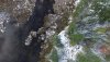
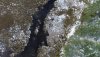
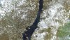
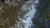
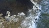
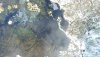
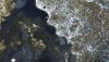
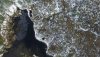
I'm trying to create an orthomosaic of a beaver pond using imagery I collected with my Inspire 1 and Litchi autonomous flight software. From what I have read elsewhere, the images taken with the Inspire should be automatically geotagged. I have tried using Erdas Imagine, ArcMap, Maps Made Easy, and Drone Mapper to stitch my imagery together and none of it works. All of my images show up in the same spot. In Drone Mapper I received an error (object reference not set to an instance of an object) and only one of my images appeared but it has lat and long data. The best guess I have is that all my photos were geotagged using the same point. Is this an issue with Litchi? Something else? Is there a better software to use? (I can not afford Pix4D) I can't figure out the issue. This is very important to my research and I feel completely stuck. I still have time for test flights before my field season this fall. And don's hesitate to be hyper-detailed. Thanks. I will attach the images I have too if that will help. These images were taken at 250AGL I can't find my specs sheet but the endlap and sidelap should be 70% and 35%.
I'm trying to create an orthomosaic of a beaver pond using imagery I collected with my Inspire 1 and Litchi autonomous flight software. From what I have read elsewhere, the images taken with the Inspire should be automatically geotagged. I have tried using Erdas Imagine, ArcMap, Maps Made Easy, and Drone Mapper to stitch my imagery together and none of it works. All of my images show up in the same spot. In Drone Mapper I received an error (object reference not set to an instance of an object) and only one of my images appeared but it has lat and long data. The best guess I have is that all my photos were geotagged using the same point. Is this an issue with Litchi? Something else? Is there a better software to use? (I can not afford Pix4D) I can't figure out the issue. This is very important to my research and I feel completely stuck. I still have time for test flights before my field season this fall. And don's hesitate to be hyper-detailed. Thanks. I will attach the images I have too if that will help. These images were taken at 250AGL I can't find my specs sheet but the endlap and sidelap should be 70% and 35%.