Welcome Inspire Pilots!
Join our free DJI Inspire community today!
Sign up

New Flyer, Questions ...

Joined
Mar 16, 2021
Messages
104
Reaction score
21
Folks

I, am, confused.

I live in a small town of 3250. In a quiet neighborhood near the edge of town. West Central Mn. Common sense dictates not to annoy my neighbors nor fly where an airplane might be. The last thing I want to do is have folks descend on me and give me trouble. I have a fun, meaningful project in mind for the summer.

I purchased an Inspire I v2 Pro with X5 camera, normal lens. Have learned alot of the drone itself and battery management. It has not seen any flying yet. I have flown RC airplanes for many years on AMA fields.

I am concerned of receiving permission anywhere I fly and inform the Sheriff/Police dept in case someone calls in. They both expressed gratitude. I have checked with the local Airport Manager who mentioned an area outside of town with a good sized field. Even tho the main use of the airport is for the local Agwagon to fly in and out of. With generous clear fields to the west.

I signed up with the FAA for a Recreational Permit. One placed on the Inspire, the other in my billfold. I have started a log. Everything I have done to it, parts ordered, battery conditioning/charging, etc. People called. I am also aware of the Part 107 test. And one day, would find it useful to have. I will also log every flight and download the flight path.

I understand the Rec Permit allows me to fly for my own amusement, make pictures or movies, bring them home and watch them on my monitor. I can not post them anywhere online such as YouTube, Facebook etc. I am not clear if I can post them on my own Website. Which I have. I can not charge nor receive any money for them. I can not even give them away to a NonProfit Organization. Like the local Historical Society. How about my realtives and friends? My wife at work??

Above my house, the iPhone App, B4UFLY says I am "Clear for Takeoff". "No active adviseries. Maintain situational awareness". Btw, it also states that same thing at our airport. (KBB) West Central Mn. And a jail near town.

The DJI GO App tells me on the iPhone Screen I have an airport nearby from the No Fly database. The Jail is highlighted and the Airstrip itself has an Altitude warning. I read of the altitude calcs. So what do I do with that info?

One question I have. VFRMap.com has a five mile radius around airports in my city and neighboring towns. I am confused. Does that mean there is no drone flying within that area?

Another is, the airport mgr mentioned he may have to alert FAA folks in a larger airport nearby of my flights. I am confused as the answers I got were not clear. Really?

I have read of the FAA requiring drones in the near future, to send telemetry thru the Internet to the FAA or their Contractor. That sounds like a good idea. But, I buy a $300 drone at Walmart and ?? What happans if where one flies doesn't have WiFi nor a decent cellular signal? Will that whole thing turn out like the CB radio craze that went from Licensed Operators to anything goes?

Right now, I am really discouraged. Where is the Fun in any of this? Always concerned of the FAA requirements? And may just cut my losses.

Thanks for any help ...
 
  • Like
Reactions: Droneted
Folks

I, am, confused.

I live in a small town of 3250. In a quiet neighborhood near the edge of town. West Central Mn. Common sense dictates not to annoy my neighbors nor fly where an airplane might be. The last thing I want to do is have folks descend on me and give me trouble. I have a fun, meaningful project in mind for the summer.

I purchased an Inspire I v2 Pro with X5 camera, normal lens. Have learned alot of the drone itself and battery management. It has not seen any flying yet. I have flown RC airplanes for many years on AMA fields.

I am concerned of receiving permission anywhere I fly and inform the Sheriff/Police dept in case someone calls in. They both expressed gratitude. I have checked with the local Airport Manager who mentioned an area outside of town with a good sized field. Even tho the main use of the airport is for the local Agwagon to fly in and out of. With generous clear fields to the west.

I signed up with the FAA for a Recreational Permit. One placed on the Inspire, the other in my billfold. I have started a log. Everything I have done to it, parts ordered, battery conditioning/charging, etc. People called. I am also aware of the Part 107 test. And one day, would find it useful to have. I will also log every flight and download the flight path.

I understand the Rec Permit allows me to fly for my own amusement, make pictures or movies, bring them home and watch them on my monitor. I can not post them anywhere online such as YouTube, Facebook etc. I am not clear if I can post them on my own Website. Which I have. I can not charge nor receive any money for them. I can not even give them away to a NonProfit Organization. Like the local Historical Society. How about my realtives and friends? My wife at work??
As with everything having to do with the law... it depends. You can give them to relatives and friends including wife for their personal enjoyment. You could put them on your website or social media to share them with friends and colleagues. However, what you couldn’t do for example is use them on your company website to promote your business.

Giving them to non profits really depends on the context. You are welcome to ask about a certain context but it’s a complex situation I don’t want to bog you down with at this point in your learning.
Above my house, the iPhone App, B4UFLY says I am "Clear for Takeoff". "No active adviseries. Maintain situational awareness". Btw, it also states that same thing at our airport. (KBB) West Central Mn. And a jail near town.

The DJI GO App tells me on the iPhone Screen I have an airport nearby from the No Fly database. The Jail is highlighted and the Airstrip itself has an Altitude warning. I read of the altitude calcs. So what do I do with that info?
So you have FAA rules and DJI’s GeoZones which sometimes overlap but rarely are they exactly the same. FAA rules are the legal bit where DJI GeoZones are there to prevent people from doing something stupid or dangerous but aren’t meant to stop someone from doing something illegal that they DJI doesn’t think is dangerous or stupid so important to look at both.

For instance, flying over a county jail is not against FAA regulations (though flying over a federal prison is) but DJI will restrict the aircraft from flying directly over all jails and prisons. Falls under the stupid but not dangerous from above.

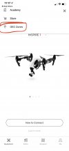
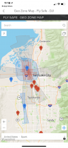
The best way to approach this is to check AirMap (highly recommended using AirMap over B4Ufly) and if it’s clear then to check the DJI GeoZone map which can be found in the DJI Go app
AFEB50CC-685D-46D9-9A41-6366FFF3AC0F.jpeg

an be found in the ACEEF366-4207-4A1F-958C-5A22F96CC65B.jpeg
0A475B6A-EB6B-4FF9-A4E4-788535D4A25A.png
One question I have. VFRMap.com has a five mile radius around airports in my city and neighboring towns. I am confused. Does that mean there is no drone flying within that area?
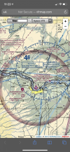
You need to tell us exactly where this is for us to give you good information. The VFR charts are complex and depending on the circles and the context of the larger map can mean you do need authorization to fly there or you do not authorization to fly there. Note that needing authorization isn’t the same as you can’t fly there. In all likelihood you are referring to faded magenta circles which means it’s ok to fly in many contexts but if you want verification you’ll need to give us the names of the airports and the general location you are looking at.

B4Ufly and AirMap are tools you can use that don’t require needing to understand these VFR charts. Most of what is on the chart isn’t relevant to UAVs. The FAA has made a “chart” specifically for UAVs which can be found here ArcGIS Web Application

This is what the information on B4Ufly and AirMap is primarily based on
8A51D2A1-E951-494E-91B1-8F7D93C7BA8B.png
Faded magenta circle around non-towered airport. Ok to fly here
Another is, the airport mgr mentioned he may have to alert FAA folks in a larger airport nearby of my flights. I am confused as the answers I got were not clear. Really?
YAgain we need specifics about which airport but there is an automated process for getting authorization to fly near larger towered airports called LAANC and so you don’t need to call airports and offer it is counter productive.
I have read of the FAA requiring drones in the near future, to send telemetry thru the Internet to the FAA or their Contractor. That sounds like a good idea. But, I buy a $300 drone at Walmart and ?? What happans if where one flies doesn't have WiFi nor a decent cellular signal? Will that whole thing turn out like the CB radio craze that went from Licensed Operators to anything goes?
We know it won’t require cell service but we don’t know all the specifics yet so standby the next few years while the specifics are worked out. There’s no need to worry about this yet. Drones under 250 grams don’t require anything so that’s what will happen with drones bought at Walmart for the most part.
Right now, I am really discouraged. Where is the Fun in any of this? Always concerned of the FAA requirements? And may just cut my losses.
If can be overwhelming at first but it really isn’t that bad especially for recreational pilots. It’s actually the exact same for RC planes.
Check out the rules overview for recreational pilots Recreational Flyers & Modeler Community-Based Organizations

Main points;
Check AirMap before flights
Check DJI GeoZones before a flight
Keep aircraft within your sight at all times
Fly below 400’ above the ground
Avoid manned aircraft
Don’t be reckless

Pretty simple actually
 
Last edited:
  • Like
Reactions: John Gullam
As with everything having to do with the law... it depends. You can give them to relatives and friends including wife for their personal enjoyment. You could put them on your website or social media to share them with friends and colleagues. However, what you couldn’t do for example is use them on your company website to promote your business.

Giving them to non profits really depends on the context. You are welcome to ask about a certain context but it’s a complex situation I don’t want to bog you down with at this point in your learning.

So you have FAA rules and DJI’s GeoZones which sometimes overlap but rarely are they exactly the same. FAA rules are the legal bit where DJI GeoZones are there to prevent people from doing something stupid or dangerous but aren’t meant to stop someone from doing something illegal that they DJI doesn’t think is dangerous or stupid so important to look at both.

For instance, flying over a county jail is not against FAA regulations (though flying over a federal prison is) but DJI will restrict the aircraft from flying directly over all jails and prisons. Falls under the stupid but not dangerous from above.

The best way to approach this is to check AirMap (highly recommended using AirMap over B4Ufly) and if it’s clear then to check the DJI GeoZone map which can be found in the DJI Go app
View attachment 31050

an be found in the View attachment 31051
View attachment 31053

You need to tell us exactly where this is for us to give you good information. The VFR charts are complex and depending on the circles and the context of the larger map can mean you do need authorization to fly there or you do not authorization to fly there. Note that needing authorization isn’t the same as you can’t fly there. In all likelihood you are referring to faded magenta circles which means it’s ok to fly in many contexts but if you want verification you’ll need to give us the names of the airports and the general location you are looking at.

B4Ufly and AirMap are tools you can use that don’t require needing to understand these VFR charts. Most of what is on the chart isn’t relevant to UAVs. The FAA has made a “chart” specifically for UAVs which can be found here ArcGIS Web Application

This is what the information on B4Ufly and AirMap is primarily based on
View attachment 31052
Faded magenta circle around non-towered airport. Ok to fly here

YAgain we need specifics about which airport but there is an automated process for getting authorization to fly near larger towered airports called LAANC and so you don’t need to call airports and offer it is counter productive.

We know it won’t require cell service but we don’t know all the specifics yet so standby the next few years while the specifics are worked out. There’s no need to worry about this yet. Drones under 250 grams don’t require anything so that’s what will happen with drones bought at Walmart for the most part.

If can be overwhelming at first but it really isn’t that bad especially for recreational pilots. It’s actually the exact same for RC planes.
Check out the rules overview for recreational pilots Recreational Flyers & Modeler Community-Based Organizations

Main points;
Check AirMap before flights
Check DJI GeoZones before a flight
Keep aircraft within your sight at all times
Fly below 400’ above the ground
Avoid manned aircraft
Don’t be reckless

Pretty simple actually

Thank you for the response. I will look at all the things you referenced.

My local airport is at Benson Mn (KBBB). We also have an emergency Helipad near our hospital.

My intentions are to enjoy this drone. And, not be an irritation to anyone nor the source of any danger. If I get good enough, my project is to document the rural churches of Swift County. Find those that are responsible for each one and receive permission and let them know when I would fly over their property. Put it all together and let anyone who wants it, have it. On the latter, I would be far more comfortable with a Part 107 in my hands bfore starting any of this. Which would make things alot easier.

Thank you very much ...

Jon ...
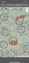
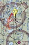
You are in a pretty good place to fly! No restrictions in sight. Only controlled airspace in the vicinity is Chandler Field.

The faded magenta circles you were seeing, as I suspected denote that Class E airspace starts at 700’ AGL above where we are allowed to be with drones anyway so you can fly inside them.
07F98B93-3FF8-4386-A1F4-87AE139853E8.jpeg

If you look at Chandler Field however you’ll see that there is also a dashed magenta line which denotes class E airspace starts at the surface so you’d have to use AirMap or similar to get authorization to fly inside that dashed line.
06DEDD7B-71AD-461F-ACEE-5AE50FA7EF29.jpeg
Chandler is LAANC enabled so all you’d need to do is submit a flight plan on AirMap to get automatic authorization to fly there. No need to call anyone

if we look at AirMap you can see they’ve spelled it out for you. You can get authorization to fly up to the height indicated in the boxes. So if you want to fly in a box that says 100 you’d only be able to get authorization to fly up to 100 ft in that box. If you want to fly in the boxes that say 0 or higher than than indicated in the box you’d need a part 107.
74EEB07B-54FB-4A17-AB5B-1A8CD37B283C.pngThis process for authorization is automatic and instant so it’s very easy and you know right away what your limits are.

As far as your goal of taking photos of the churches and compiling a photo database of the photos that is recreational and doesn’t require a part 107. What would make it require a part 107 is if the churches came to you and asked you to do it. Frankly even that is a gray area but basically if you are doing for your own personal enjoyment then you are good. If you are doing something at someone else’s request it probably requires part 107
 
Brett8883

You have simplfied for me, what was a confusing set of guidelines. Thank you.

You are very kind.

Jon ...
 
Brett8883

Have explored all the programs suggested. Including Laanc Aloft.
I am coming to the conclusion, out here, I can fly just about anywhere. Except the Jails around me. I will have to bring the drone in my car, powered on and see what DJI Go tells me from the database it has.
The City Manager stated I can fly above town etc. Just be careful not to anger anyone.
The Airport Manage referred me to sites that were not usable. State land. County land. No access.
But it appears, even in State Law, I can fly from the airport. I would never use the runway nor approach nor buildings nor any ofthat. But there is a large field west of everything that would be poerfect for my use. Just to shake this drone down and learn how to use the camera, video and paths flown.
So
Next week, I will set down face to face with the Airport Manager and bring some pie or cookies. And in the best cordial way I can muster, see where this leads.
Wish me well ...

Jon ...
 
Brett8883

Have explored all the programs suggested. Including Laanc Aloft.
I am coming to the conclusion, out here, I can fly just about anywhere. Except the Jails around me. I will have to bring the drone in my car, powered on and see what DJI Go tells me from the database it has.
You can use the GeoZone map in the app (I showed you how to access in my first post above) and put in an address to see if there are GeoZone restrictions from DJI so you don’t need to physically take the drone places to figure that out. You are right though. Probably just directly over the jails where you’d be restricted.

Alternatively you can go to Geo Zone Map - Fly Safe - DJI

to check by address.
The City Manager stated I can fly above town etc. Just be careful not to anger anyone.
The Airport Manage referred me to sites that were not usable. State land. County land. No access.
But it appears, even in State Law, I can fly from the airport. I would never use the runway nor approach nor buildings nor any ofthat. But there is a large field west of everything that would be poerfect for my use. Just to shake this drone down and learn how to use the camera, video and paths flown.
So
Next week, I will set down face to face with the Airport Manager and bring some pie or cookies. And in the best cordial way I can muster, see where this leads.
Wish me well ...

Jon ...
Good luck!
 
You can use the GeoZone map in the app (I showed you how to access in my first post above) and put in an address to see if there are GeoZone restrictions from DJI so you don’t need to physically take the drone places to figure that out. You are right though. Probably just directly over the jails where you’d be restricted.

Alternatively you can go to Geo Zone Map - Fly Safe - DJI

to check by address.

Good luck!
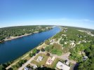
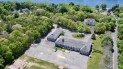
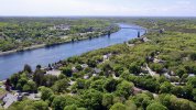
If I get close to an airport my dji drone will not climb over ten feet and is uncontrollable even though b4ufly says all is clear. You have to jump through a few hoops, but you can usually clear yourself with dji unlocking software. I’m lucky I have 2 great places to fly, one near the Cape Cod Canal. I’ve included a few pictures. I love my Inspire, but it can be intimidating to the uninformed. Flying a Spark or Mavic Mini doesn’t seem to frighten anyone. By the way I fly the GoPro Karma, Mavic 2 Zoom, Phantom 4 Pro and the Inspire. Love them all.
 

Attachments

  • 7EBE56E9-78D7-4202-BE54-9FDB1B1C7EE2.jpeg
    7EBE56E9-78D7-4202-BE54-9FDB1B1C7EE2.jpeg
    5.6 MB · Views: 2
  • 2AF6668C-748A-43C1-8709-42A74BA63892.jpeg
    2AF6668C-748A-43C1-8709-42A74BA63892.jpeg
    5.2 MB · Views: 2
  • 806C7BAB-BFB1-4C97-9198-FCFC5B67EC31.jpeg
    806C7BAB-BFB1-4C97-9198-FCFC5B67EC31.jpeg
    4.8 MB · Views: 2

New Posts

Members online

No members online now.

Forum statistics

Threads
22,363
Messages
210,996
Members
35,590
Latest member
CorinaAltm