Skyvector displays aviation charts, the most usable to sUAS would be the VFR Sectional chart. The problem with that, is it is meant for enroute navigation, and not precision ground measurements. I use Skyvector as a tool to build a better product. This is what I do. It may work for you too.. if it does.. please feel free to pass the word.
1- Download and Install Google Earth Pro (it is now free)
2- Open it up and zoom in toward the airport in question:
3- Open up SkyVector and zoom in to the airport that you are looking for. For those that are not manned aircraft pilots, I will spell this out in order to help every skill level. Next to the airport you will see three letter/number combination in parenthesis. That is the Airport Identifier.
4- Take that identifier, click on the icon on the top left that says Airports, and then type that three digit code into the box. There may be more than one that pops up, click on the airport that you are searching for.
5- At the very top of that airport information you will see the "Airport Reference Point (ARP)" This is the point that all measurements are taken from Copy the entire LAT/LONG and then go back to Google Earth Pro.
5- Paste that LAT/LONG into the search box in the top left corner. Google Earth Pro will zoom into that point and then place a Tack onto the map.
6- Below the search bar will be the LAT/LONG. Right click on it and select "Save to My Places". Right Click on it under My Places and rename it to the three digit identifier. As an option, you can also click on the on the "Tack" icon to the right of the name and select a different icon. For airports... I select the airplane.
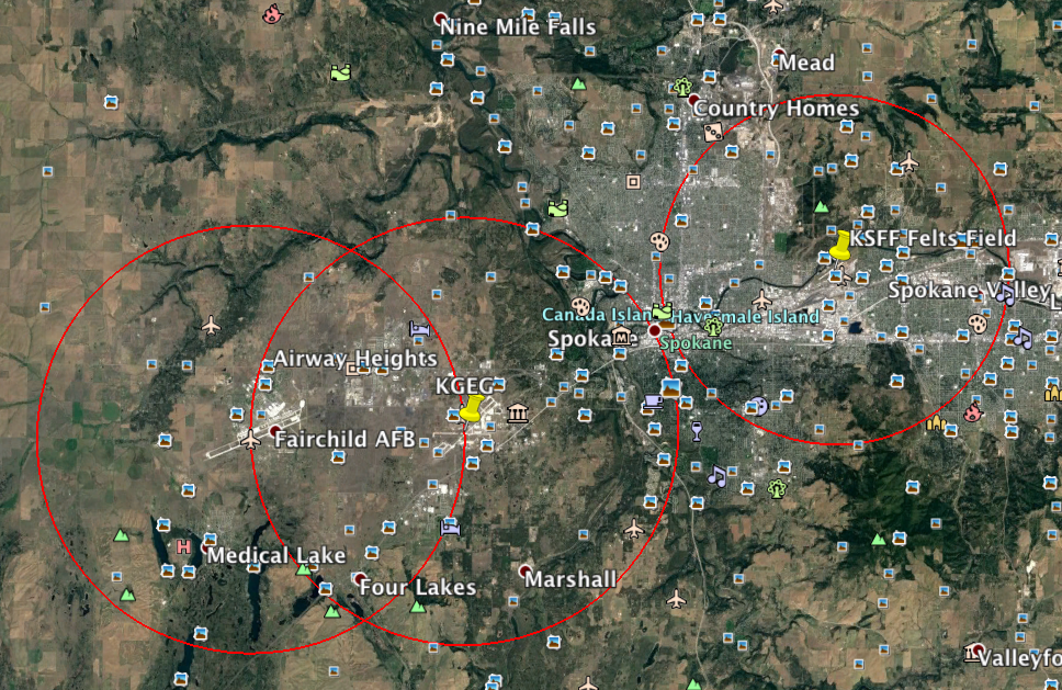
7-This whole exercise has led up to this step... placing the distance ring around that airport.
8- Zoom into your newly created icon, and then select the ruler (this is why we needed Google Earth Pro, and no Google Earth). Click on the Circle Tab on top and then change the measurements to Nautical Miles.
9- Make sure you are zoomed all of the way in and place the reticle directly over the center of your newly created icon. Start dragging it out until your measurement reads 5 nautical miles. (as a general rule, surface based airspace extends 5 nautical miles from the airport reference point).
When you are done, you click SAVE. I typically save mine as the airport identifier followed by this: 5nm It looks like this: SFF 5nm
10-: Now to clean this all up, I add folders to "My Places". One for Airports and One for Distance Rings. I place them in their respective folders AND CLICK FILE / SAVE / MY PLACES
11- Now, you can type in any address that you plan on flying and see exactly where you are in reference to an airport surface based airspace.
12- I also put navigational aids on the map as well. When you file NOTAMS with the FAA, they want the distance from the closest NAVAID (if it's within 20 nautical miles). They also want the magnetic bearing from the NAVIAD to your proposed location.
13: ** NOTE * Make sure you take into account the MAGNETIC DEVIATION which which can be found on the airport's page on SkyVector. For the airfield KSFF, which is what I used in the example above, in the same box that gave you the LAT/LONG you will find something like this: Magnetic Variation from 2010 is 16° East. Because it is East, I subtract.
I know that was a lot of steps, but once you get your local flying area set up, and SAVED, you can easily type in an address and quickly tell your clients whether or not you need to file for an airspace authorization. I keep mine on my laptop so it is always with me.
Hope this helps in getting accurate distance measurements


")