- Has anyone experienced the UAV (Inspire 1) start a Litchi orbit with an actual orbit center that does not match the planned center point placed on the Litchi satellite image?
- If so, what was the cause & prevention for recurrence?
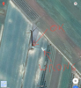
I ask because I set a 36' radius orbit around a center point and the UAV flew an orbit where the center point did not match the point on the map, resulting in a crash into a tree. Seemed like the actual center point was off by about 30'.
Thanks.