Welcome Inspire Pilots!
Join our free DJI Inspire community today!
Sign up

Are drone land surveys better than traditional surveys in terms of cost?

Joined
Apr 2, 2022
Messages
1
Reaction score
0
Age
23
There is no doubt that drone surveys are better than traditional surveyor option. But are it's costs viable?

As per my
research, the national average drone land survey can cost between $30 and $120 per acre. It can be even higher or lower than that depending on the type of survey and the amount of time needed to complete the work. The average hourly cost of a drone survey is $26 / hour. After all the calculations, I came to the conclusion that a drone land survey costs an average of $100 while a traditional one costs on average $517!

So drone land surveys should rule in US. What do you guys think? Share it in the comments.
 
Going down the rabbit hole...

I work in conjunction with survey crews. At this point, as far as I know, there's no such thing as a true "drone survey." Even enterprise RTK drones aren't accurate enough GPS-wise to satisfy industry tolerances. 1"/pixel is our minimal accuracy with as little as 1/2"/pixel for some clients.

Drone photos have to be tied to Ground Control Points, that have to be surveyed by a professional surveyor. If you're just making mosaics, then of course accuracy doesn't matter. But if you're making a true "map," then you need to have surveyed GPC's.

That said, I'm not a surveyor. I work for a survey company. So if anybody knows any better, please feel free to chime in.

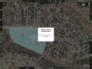
Worth noting; This partnership between survey company and drone is a house of cards. 50 things have to go right for BOTH of us to deliver a finished, accurate product. Case in point, I did my preflight research and drove 90 miles to a jobsite, set up my spare drone just to be met with this ChinEnglish failure:
1648915293239.png

Keep in mind that survey crews had also traveled 90 miles and planted and surveyed a dozen GCP's the day before and were standing by to collect these GCP's post mission. So the entire job hinged on my photos - my flights. Yet here I was staring at a ChinEnglish warning telling me my mission will "across" the no fly zone. As you can imagine, for a second my heart sank into my stomach!

This parcel is over 5 miles from a Class D airport with no NFZ's or NOTAM's for that area for that day. This is just another one of those random, erroneous DJI NFZ bugs that prompted me to hack my drones in the first place. Fortunately for all of us, my MAIN P4P is hacked. I simply put away the spare (I fly the spare occasionally just for grins), loaded the mission into my main P4P and flew the mission. Talk about job security.

A few weeks ago I had another issue. Of the dozen flights I had done that day, ONE mission was *slightly* out of focus. How it works; once the drone reaches altitude, it auto focuses before snapping the first photo. I always watch to make sure the drone goes through the autofocus routine. I learned that day that just because the drone goes through the focus routine does NOT always means that it focuses 100% all of the time.

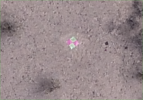
Here's what a properly focused photo of a GCP looks like from 250' AGL (Digitally zoomed):
1648916112789.png

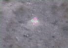
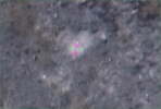
On this day, ONE of my missions was "soft." This is the result (digitally zoomed):
1648916432178.png

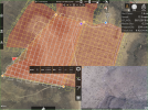
Fortunately, I always "over collect," so there's a little wiggle room for small mistakes. Keep in mind the "soft" photos accounted for < 5% of the total day's collection. But a lesson was learned. I must be VERY diligent regarding focus (which is hard to see in a corner window on a 12.9" iPad:
1648916899229.png

I guess my point is, if you're going to put all your eggs in a drone basket, you better have a drone operator INTIMATELY familiar with the drone, the software, the firmware and all the inner workings of the process. Despite the rhetoric, there's a lot more to this than simply setting up a Pix4D account, buying a drone and collecting photos.

D
 
Last edited:
  • Like
Reactions: CoreySnipes
The picture looks like it was taken with low light, and the shutter speed too slow as a result causing the blur. Are you sure it's out of focus?
 
The picture looks like it was taken with low light, and the shutter speed too slow as a result causing the blur. Are you sure it's out of focus?
It was shot with shutter priority. So shutter and ISO were locked down @ 1/1000 and ISO 200 respectively. 1/1000 is more than fast enough to quell motion blur. At 250' AGL, the drone flies about 17 mph.

The entire series (1 battery) was soft - even the well-lit shots. The previous example was the only shot that I could find a GCP. It was shot in the shadow of a cloud on a partly cloudy day.

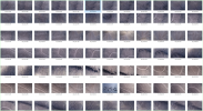
After searching some more, I found a better-lit example:
1648997696674.png


The P4P definitely has a hard time properly exposing photos on partly cloudy days. But we over-shoot so if the photo is a bit underexposed on the first pass, it's usually better-exposed on the second pass. That said, none of the shots are so underexposed that it's a problem.

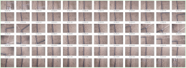
Check out this contact sheet from a cloudy day. As you can see, it's an exposure nightmare.
1648997914041.png

My client adjusts exposure in post if need be. This kind of exposure inconsistency is rare, but is easily rectified in post. Nothing is ever so underexposed (crushed) that its unusable. "Exposure" is yet another item in the long list of problems that can ruin an entire day's work.

Here's another contact sheet of the same property on the same day, but maybe 3 minutes later:
1648998171459.png

As you can see, the sun poked its head out, completely changing the exposure profile.

One of the features of this software is the ability to keep an eye on the aperture in real time. So if the aperture spends too much time fully open (f/2.8), I audit the photos and make adjustments.

If I recall, on this particular day there was a thunderstorm brewing not more than 10 miles South of my location. So there were some pretty dark "moments" during my shooting day.

As a side note, I have learned to never use auto WB, because then photo color temperatures are all over the map, making the photos pretty much unusable. It doesn't matter where I set the color temp is as long as its in the ballpark and consistent across the entire day. This particular software doesn't allow for custom color balance settings. There are only 3 choices; Auto, Cloudy, Sunny. So I'll pick either cloudy or sunny, depending on the day. Partly cloudy days I flip a coin.

D
 
Last edited:
Donnie, a couple of tips using MPP which I typically use as well with P4Ps.

Exposure. I also use Shutter Priority, but I suggest you leave ISO on auto and not fixed. You probably have the experience to select a good shutter speed for conditions, and on auto, the ISO will adapt AFTER the aperture reaches max opening. This will enable you to get a lot of your imagery with an ISO of 100 and only raise it in the darker areas. Another interesting thing is that MPP only shows ISO as major settings, 100, 200, etc. But when left on auto, the camera will raise the ISO incrementally, 100, 120, 160, 200. Again, another way to improve the image set. If you happen to select a shutter speed that is too fast for conditions and you see that the ISO is trending too high, you can abort and reset to a lower shutter speed. If it trends higher than you wanted it wouldn't have helped anyway if it was locked at the lower ISO seitting. The imagery would just be too dark.

Focus. A good focus depends on decent contrast. When MPP pulls focus at the top of the climb, it usually is successful but not always. What I do is let the craft reach mission height and begin to head to the first waypoint. When I see a really good contrasting piece of ground I pause the mission with the pause button on the RC and after the craft stops, tap on the camera feed over the best contrast spot, just like typical photography in the GO app, and MPP will pull focus again and will display a "focus success" notice up toward the top/center-right of the app just below the controls. It is great not leaving focus to chance.
 
Donnie, a couple of tips using MPP which I typically use as well with P4Ps.

Exposure. I also use Shutter Priority, but I suggest you leave ISO on auto and not fixed. You probably have the experience to select a good shutter speed for conditions, and on auto, the ISO will adapt AFTER the aperture reaches max opening. This will enable you to get a lot of your imagery with an ISO of 100 and only raise it in the darker areas.
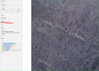
Well, here's some interesting information. Check out this screen shot. As you can see, the photo is pretty dark. But notice the aperture is @ f/3.2. As you know, the P4P aperture opens up to f/2.8. So if MMP is incapable of opening the aperture quickly enough to adjust for cloudy areas, why would we think that MPP could adjust the ISO quickly enough?? Just food for thought.

BTW, I'm aware that MMP is limited to the drone's hardware capabilities and DJI's SDK limitations.

1649003714995.png

That said, I'll consider Auto ISO. I can't imagine the ISO going over 300 on even the darkest days. If it's super dark (cloudy), I've been known to lower shutter to 1/800. @ ISO 200 this pretty much insures proper exposure regardless of how cloudy it is with no motion blur. After 6 years of mapping, unusually dark storm clouds on a partly cloudy day caught me a bit off guard this one time. But I will experiment with Auto ISO. I generally don't like Auto settings and therefore avoid them. But I'll give Auto ISO a shot.


Another interesting thing is that MPP only shows ISO as major settings, 100, 200, etc. But when left on auto, the camera will raise the ISO incrementally, 100, 120, 160, 200.
Hmmmm....I did not know that. Interesting.


Focus. A good focus depends on decent contrast. When MPP pulls focus at the top of the climb, it usually is successful but not always. What I do is let the craft reach mission height and begin to head to the first waypoint. When I see a really good contrasting piece of ground I pause the mission with the pause button on the RC and after the craft stops, tap on the camera feed over the best contrast spot, just like typical photography in the GO app, and MPP will pull focus again and will display a "focus success" notice up toward the top/center-right of the app just below the controls. It is great not leaving focus to chance.
I have used this routine many times. The problem is the small viewing screen in MPP. The user can't "full screen" the image. So even on a 12.9" screen, *slightly* out of focus images are hard to spot. That said, it's not uncommon for me to pause the mission and double-tap the viewing area to refocus.

Worth noting, most of my mapping is in undeveloped areas. So there's often no roads or buildings to provide contrast. In these situations, my vehicle is about the only high-contrast item. I have been known to pause on my vehicle and refocus. This is mostly because the drone seems to try to focus while it's still running its GPS routine, which is to rotate left and then rotate right. It would make more sense for the drone to be completely still when acquiring focus. If I notice that focus is garnered while the drone is still rotating, I *will* pause it and refocus.

Also, when the bird is flying out to its first waypoint at top speed, it's pretty much impossible to scrutinize the smallish view screen to find high-contrast opportunities and stop the drone in time. But even then, this kind of focus issue rarely pops up. I just have to be more diligent.

D
 
Last edited:
Well, here's some interesting information. Check out this screen shot. As you can see, the photo is pretty dark. But notice the aperture is @ f/3.2. As you know, the P4P aperture opens up to f/2.8. So if MMP is incapable of opening the aperture quickly enough to adjust for cloudy areas, why would we think that MPP could adjust the ISO quickly enough?? Just food for thought.
I can't say on your example. But MMP does not adjust the camera settings on the fly. It just sets them up as specified and then the camera operates on it's own.

As for the ISO. I can say it adjusts because that's what I have used many, many times. Try it and see. It's just a setting away. If you don't like it, change it back.

Also, when the bird is flying out to its first waypoint at top speed, it's pretty much impossible to scrutinize the smallish view screen to find high-contrast opportunities and stop the drone in time.

Okay. I guess I don't have that problem.
 
First of all I’m not a surveying expert by any any means so take this with a grain of salt but my understanding is if you do a photometric survey using a non RTK drone the result is very accurate on a relative basis. For instance, figuring out how far point A is from point B on the survey is extremely accurate. However, the absolute accuracy of the map is not so reliable without ground control points. By absolute accuracy I mean how close the GPS position of point A is on survey to the actual GPS location of point A in the world. So if you wanted to measure the distance from point A on the survey to a point B that is on a different survey, now you are in trouble because there is no actual way to measure the absolute accuracy of a drone survey without using traditional survey tools to verify. This is why ground control points are used, by matching known absolute points in the real world with points on the survey the drone survey will have good absolute accuracy.

However, if you use a dual RTK antenna drone like the M300 RTK and use one of those D-RTK base stations that’s essentially the same technology that traditional professional surveyors use. The only difference is they use a little car to drive along the terrain instead of a drone. This provides absolute accuracy as well as relative accuracy.

With a traditional survey what you are really paying for is a trained certified professional with experience to put their professional reputation and therefore livelihood on the line when they send you their survey and tell you that it is correct. That’s just like any other business honestly.
 
Last edited:
I can't say on your example. But MMP does not adjust the camera settings on the fly. It just sets them up as specified and then the camera operates on it's own.
In shutter priority mode, MMP adjusts the aperture on the fly. I can attest to this.


As for the ISO. I can say it adjusts because that's what I have used many, many times.
I don't doubt your veracity. I said I would give it a shot.


Try it and see. It's just a setting away. If you don't like it, change it back.
Yep. Already said I would give it a shot.


Okay. I guess I don't have that problem.
At 32 mph, the tiny view in the small FPV window whizzes by pretty quickly. Add to the mix at least 500ms of video latency, if not more, and I think you see my point. But you have to imagine an open mesa of nothing but dirt, weeds and cactus (high desert), with nothing but the occasional dirt road or tire to break up the landscape. I'm just saying that it's difficult to stop the drone in time to catch these objects. Even more, the drone doesn't stop on a dime. It takes about 20-30 feet to stop. And I'm not even considering the latency it takes the drone to receive the pause command after you hit the pause button.

If this isn't an issue for you, the only thing I can think of is that you are either mapping more diverse landscapes that offer better/higher contrast or you're flat-out mapping plots of land with man-made structures on them.

D
 
In shutter priority mode, MMP adjusts the aperture on the fly. I can attest to this.
No, MMP tells the camera to use Shutter Priority Mode. Then the camera obeys. MMP does not process and command when to change the aperture, or any other similar adjustments. That is the camera's job. To the end user, it makes no differences so long as it works. But under the hood, that is what is happening. Thus my answer.
But you have to imagine an open mesa of nothing but dirt, weeds and cactus (high desert), with nothing but the occasional dirt road or tire to break up the landscape.
Yeah totally different problems up here with 150' conifers, cliffs, and super low sun angles in winter.
 
First of all I’m not a surveying expert by any any means so take this with a grain of salt but my understanding is if you do a photometric survey using a non RTK drone the result is very accurate on a relative basis. For instance, figuring out how far point A is from point B on the survey is extremely accurate. However, the absolute accuracy of the map is not so reliable without ground control points. By absolute accuracy I mean how close the GPS position of point A is on survey to the actual GPS location of point A in the world.
Basically true. But the larger the project gets the less relative accuracy you get with photometric photogrammetry as well. That is, that points close together will stll be "reasonably" accurate. But points far apart may be less so, even within the same model. Warping tends to occur over distance creating inaccuracy within the project.

With proper processing and using accurate gcps, the non-rtk drone captured imagery can be used to create centimeter level results as well as the rtk equipped drone. GCP checkpoints are still necessary to prove the results. At least for now.
 
  • Like
Reactions: Brett8883
No, MMP tells the camera to use Shutter Priority Mode. Then the camera obeys.
Well, as I stated earlier:
1649039684081.png


MMP does not process and command when to change the aperture, or any other similar adjustments. That is the camera's job.
Yep...I'm aware of the hierarchy and how it works. So I'll rephrase. The camera adjusts the aperture on the fly and then reports those changes to MMP, who then shows those changes to the end user in real time. Semantics.


To the end user, it makes no differences so long as it works. But under the hood, that is what is happening. Thus my answer.
Touché.


Yeah totally different problems up here with 150' conifers, cliffs, and super low sun angles in winter.
Yep.

D
 
First of all I’m not a surveying expert by any any means so take this with a grain of salt but my understanding is if you do a photometric survey using a non RTK drone the result is very accurate on a relative basis. For instance, figuring out how far point A is from point B on the survey is extremely accurate. However, the absolute accuracy of the map is not so reliable without ground control points. By absolute accuracy I mean how close the GPS position of point A is on survey to the actual GPS location of point A in the world. So if you wanted to measure the distance from point A on the survey to a point B that is on a different survey, now you are in trouble because there is no actual way to measure the absolute accuracy of a drone survey without using traditional survey tools to verify.
If you only need to be accurate to within a couple feet, then the drone's GPS will work for your needs. But architects, construction companies and engineers need the data to be accurate within about an inch.


This is why ground control points are used, by matching known absolute points in the real world with points on the survey the drone survey will have good absolute accuracy.
Correct.


However, if you use a dual RTK antenna drone like the M300 RTK and use one of those D-RTK base stations that’s essentially the same technology that traditional professional surveyors use.
"Essentially" perhaps. But not exactly. The RTK is still not accurate enough. Believe me, the day RTK becomes accurate enough for survey grade maps, we will save the thousands of dollars it takes to send survey crews out to job sites. I've been looking into it since RTK first hit the market. As of this writing, it's still not accurate enough.


The only difference is they use a little car to drive along the terrain instead of a drone. This provides absolute accuracy as well as relative accuracy.
I'm not sure what you're talking about here. Sounds like you're talking about LIDAR, which is something completely different.


With a traditional survey what you are really paying for is a trained certified professional with experience to put their professional reputation and therefore livelihood on the line when they send you their survey and tell you that it is correct.
Correct.


That’s just like any other business honestly.
In a nutshell, drone GPS/RTK simply isn't accurate enough *yet* to warrant laying off surveyors. I imagine we'll see improvements in RTK within the next 5-10 years that will allow us to use drones alone for survey work. But that technology doesn't exist today.

D
 
There is no doubt that drone surveys are better than traditional surveyor option. But are it's costs viable?

As per my
research, the national average drone land survey can cost between $30 and $120 per acre. It can be even higher or lower than that depending on the type of survey and the amount of time needed to complete the work. The average hourly cost of a drone survey is $26 / hour. After all the calculations, I came to the conclusion that a drone land survey costs an average of $100 while a traditional one costs on average $517!

So drone land surveys should rule in US. What do you guys think? Share it in the comments.
$26/hr drone survey ? Not sure where you got that number from but I charge $186/hr min charge on an hourly basis.
 
  • Like
Reactions: Donnie Frank

Members online

Forum statistics

Threads
22,277
Messages
210,655
Members
34,326
Latest member
BobbyeriGop