Welcome Inspire Pilots!
Join our free DJI Inspire community today!
Sign up

How to? Sony A7Riii and accurate GPS data

Joined
Feb 21, 2018
Messages
926
Reaction score
263
Age
66
Anyone collecting GPS data tags per image when using RoninMX with Sony A7Riii ? The A7 had GPS contacts in Hotshoe, but I don’t think Sony ever completed or it’s dried up by now.

Looked at a few GPS data loggers, but accuracy was poor... in meters.
I’ve heard strapping a Garmin Felix 3 or 4 to top of platform Is an option.

Would like to collect for ground mapping or large image survey for construction or Ag.

Anyone find a way to access and trigger accurate GPS to photos or to use later with photos.
 
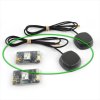
There are various kits to add an Emlid GNSS module to uas.

 
Last edited:
There are various kits to add an Emlid GNSS module to uas.

Dave, looks like a good setup!
It mounts interface on hotshoe and collects logs within the airborne unit to later process to add the geodata to photos.

That is probably the best solution, I had hoped there may have been an interface that added the geo tags to the metadata during image collection. I don't think that exists and Sony's original product never evolved.

I haven't read the Reach M2/M+ webpages yet... just skimmed. Does this solution require placement RTK Ground Units and setup or can they be used with standard GPS with slightly less accuracy?

Thanks, I'll look into these.

Doug, you can use the Emlid by itself. You'll need to rig an antenna and power to the unit. It will probably be more accurate than the drone's gps out of the box. But a lot of guys post-process the data (PPK) when highly accurate is needed. There are also some DIY workflows out there to batch embed the gps data into the photo meta data. If you can't find anything, I can see if I can dig up some sources.
 
Doug, you can use the Emlid by itself. You'll need to rig an antenna and power to the unit. It will probably be more accurate than the drone's gps out of the box. But a lot of guys post-process the data (PPK) when highly accurate is needed. There are also some DIY workflows out there to batch embed the gps data into the photo meta data. If you can't find anything, I can see if I can dig up some sources.
Dave, you beat me...I was just going to comment after "reading" the web page it can be used as a stand alone or with a base. Very nice setup! Not fully clear to me yet, but when it's used with a Base RS unit, it's dependent on NTRIP (cellular Internet) to communicate to the Rover M+/M2. It looks like when used stand alone, it only used GPS Satellites, so one could be outside cellular service and still collect GPS tags.
Also looks like the M+/M2 can be used with a Hotshoe trigger or a method to capture Zenmuse Cameras too.
If that's accurate, it's a much lower cost solution than purchasing a RTK model from DJI.

I think some of the meta data software to batch the GPS tags would be like Picmeta PIE Studio (paid), and ExifTool (open source). ExifTool by Phil Harvey and PIE Studio - EXIF IPTC & Print Software | Picmeta Systems
 
Doug, you can use the Emlid by itself. You'll need to rig an antenna and power to the unit. It will probably be more accurate than the drone's gps out of the box. But a lot of guys post-process the data (PPK) when highly accurate is needed. There are also some DIY workflows out there to batch embed the gps data into the photo meta data. If you can't find anything, I can see if I can dig up some sources.
Dave, Quick FYI... I was communicating with Emlid on purchasing the M+/M2 and the accuracy when used by itself compared with a Base.

The Emlid Rep clarified that it requires the Base RS, and not able to operate alone. I asked a 2nd time, expanded my question that I thought it would provide GPS data by itself to clarify... and again he replied the M+/M2 can not operate alone and requires the RS Base.

Still looks like a great solution for M600 SLR, but little more setup up ft than desired.
 
Doug, The module records a log and a time stamp is placed in the log at each image capture via the hot shoe connection. For ppk processing, the shorter the baseline the better. So, ideally, yes, an instrument on site recording a base log in addition to the rover log on the uav (or your hand held Sony) is best. But if there is a CORS station within acceptable range, you can use the log from that for the base corrections in vs. the log from a base. I'll see if I can dig up some links to discussion on this.


Capture.JPG
 
Last edited:
I have 2 of the original Emlid modules which does not have the enclosure but otherwise are very similar. With Tallysman antennas . I don't use them and would sell one for a good price if you ever want to try it out without going all in. They operate the same.

But the ppk workflow may be more than you want to deal with just to geo-stamp your images. I've not done any testing on how accurate the location stamps are while moving around without correction. I'm assuming better than a uas gps unti, but I haven't tested it myself.

reach-rtk-kit-multi-gnss-accurate-positioning-system-1_2.jpg


Last edited:
Here is a quick find on using the module for geo-tagging images.

 
Dave, Really appreciate the info! That does make more sense. I may take you up on that, still exploring a bit... all new to me.
Read through the module link you provided, didn't find a reference to what extra hotshoe cable or where to connect the hotshoe lead.

I'll read through your links.
I'm beginnig to think setting up a RS Base wouldn't be that long. I just thought if I was just going for non-survey grade, the base wouldn't be needed.
 
Just looked and the hot shoe connector Emlid sells is just for the newer modules. Here is a post where a guy made his own for the older module.


New Posts

Members online

No members online now.

Forum statistics

Threads
22,341
Messages
210,420
Members
36,555
Latest member
Latham324